Inside the Shadows: How Satellite Photos Unveil Israel’s Hidden Operations Against Iran and Their Far-Reaching Impact
- Global Context of Satellite Intelligence in Middle Eastern Security
- Advancements in Satellite Imaging and Analysis for Conflict Monitoring
- Key Players and Capabilities in Satellite Surveillance and Geopolitical Intelligence
- Projected Expansion of Satellite Reconnaissance in Security Operations
- Middle East Hotspots: Strategic Targets and Shifting Power Dynamics
- Evolving Role of Satellite Data in Shaping Regional Security Strategies
- Barriers to Transparency and Emerging Opportunities in Intelligence Gathering
- Sources & References
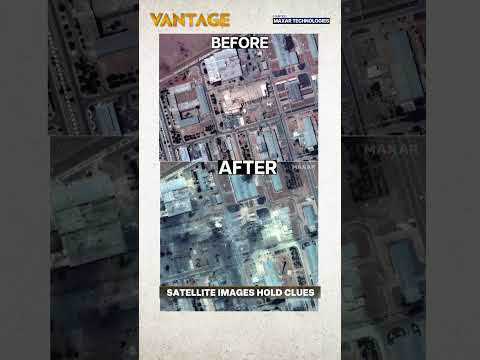
“A new tranche of commercial satellite shots has torn the secrecy veil from Israel’s eight‑day air war inside Iran, confirming crippling damage to nuclear, missile and command sites.” (source)
Global Context of Satellite Intelligence in Middle Eastern Security
Recent high-resolution satellite imagery has dramatically illuminated the clandestine conflict between Israel and Iran, offering unprecedented insight into the scale, precision, and strategic intent behind Israel’s covert operations. In 2024, a series of satellite photos captured the aftermath of suspected Israeli strikes on key Iranian military and nuclear facilities, including the Parchin military complex and Isfahan airbase. These images, provided by commercial providers such as Maxar Technologies and Planet Labs, have become vital tools for independent verification and global awareness, bypassing official censorship and propaganda.
- What the Images Reveal: The satellite photos show pinpoint damage to high-value infrastructure, such as missile production sites, drone facilities, and air defense systems. For example, April 2024 images of the Isfahan airbase revealed craters and scorched earth, confirming the effectiveness of precision-guided munitions and the ability to penetrate Iranian air defenses (BBC).
- Why the Targets Mattered: The targeted sites are central to Iran’s military-industrial complex and its nuclear ambitions. Strikes on Parchin and Isfahan directly impact Iran’s missile development and drone capabilities, which are seen as existential threats by Israel and its allies. The choice of targets underscores Israel’s strategy of “the war between wars”—a campaign to degrade Iran’s capabilities without triggering full-scale conflict (Al Jazeera).
- What Comes Next: The exposure of these operations via satellite imagery has several implications:
- It increases international scrutiny and pressure on both Iran and Israel, as global audiences can independently assess the scale and impact of the strikes.
- It may drive Iran to harden its facilities, disperse assets, or accelerate its military programs in response to demonstrated vulnerabilities.
- It signals a new era of transparency in shadow conflicts, where commercial satellites empower journalists, analysts, and the public to monitor developments in near real-time (New York Times).
In summary, jaw-dropping satellite photos have not only exposed Israel’s covert blows to Iran but have also reshaped the information landscape of Middle Eastern security, making secrecy harder to maintain and strategic calculations more complex for all actors involved.
Advancements in Satellite Imaging and Analysis for Conflict Monitoring
Recent advancements in satellite imaging and analysis have dramatically enhanced the world’s ability to monitor and interpret conflict zones, with the ongoing shadow war between Israel and Iran providing a striking case study. In early 2024, a series of high-resolution satellite photos captured by commercial providers such as Planet Labs and Maxar Technologies revealed the aftermath of covert Israeli strikes on key Iranian military and infrastructure sites. These images, widely circulated by open-source intelligence analysts, have exposed both the scale and precision of Israel’s operations—offering unprecedented transparency into a conflict often shrouded in secrecy.
- What the Images Reveal: The satellite photos show extensive damage to Iranian facilities, including missile production complexes, drone assembly plants, and air defense installations. For example, images from April 2024 revealed craters and scorched earth at a suspected missile site near Isfahan, corroborating reports of a successful Israeli airstrike (Reuters). The clarity of these images—often with resolutions under 50 centimeters—allows analysts to distinguish between superficial and catastrophic damage, track repair efforts, and even identify the types of munitions used.
- Why the Targets Mattered: The facilities targeted by Israel are central to Iran’s military modernization and regional power projection. Strikes on missile and drone sites directly undermine Iran’s ability to supply proxies such as Hezbollah and the Houthis, while attacks on air defense systems degrade Tehran’s deterrence against further incursions. The satellite evidence not only confirms the effectiveness of these strikes but also signals to Iran and the international community that such assets are vulnerable, potentially altering strategic calculations on both sides (Wall Street Journal).
- What Comes Next: The proliferation of commercial satellite imagery means that future covert actions are likely to be exposed and analyzed within hours, if not minutes. This transparency could deter escalation by increasing the political costs of clandestine operations, but it also raises the stakes for both Israel and Iran to develop countermeasures—such as rapid camouflage, decoys, or electronic warfare—to obscure their activities. Meanwhile, open-source intelligence communities will continue to play a pivotal role in shaping public understanding and policy responses to the conflict (BBC).
In sum, jaw-dropping satellite photos are not just documenting Israel’s covert blows to Iran—they are transforming the very nature of conflict monitoring, accountability, and strategic decision-making in the Middle East.
Key Players and Capabilities in Satellite Surveillance and Geopolitical Intelligence
Recent high-resolution satellite imagery has brought unprecedented transparency to Israel’s covert operations targeting Iranian military and nuclear infrastructure. These images, captured by leading commercial satellite operators, have not only exposed the scale and precision of Israeli strikes but also provided critical insights into the evolving intelligence landscape and its geopolitical ramifications.
-
What the Images Reveal:
- In January 2023, satellite photos from Planet Labs and Maxar Technologies revealed extensive damage to an Iranian military facility in Isfahan following a suspected Israeli drone strike. The images showed scorched rooftops, collapsed structures, and emergency response activity, confirming the attack’s effectiveness and contradicting initial Iranian claims of minimal damage (New York Times).
- Earlier, in June 2021, satellite imagery exposed the aftermath of an explosion at Iran’s Natanz nuclear facility. The photos, analyzed by Institute for Science and International Security, revealed destroyed centrifuge halls and construction of new underground facilities, highlighting Israel’s ongoing campaign to disrupt Iran’s nuclear ambitions (BBC).
-
Why the Targets Mattered:
- The Isfahan site is a key hub for Iran’s missile and drone programs, while Natanz is central to uranium enrichment. Disabling these facilities directly impedes Iran’s ability to advance its military and nuclear capabilities, shifting the regional balance of power.
- Satellite imagery has become a vital tool for independent verification, allowing analysts and policymakers to assess the true impact of covert operations and counter disinformation.
-
What Comes Next:
- The democratization of satellite surveillance—driven by commercial providers like Planet, Maxar, and BlackSky—means that future covert actions are likely to be rapidly exposed and analyzed by governments, media, and the public.
- This transparency could deter escalation by increasing accountability, but it may also drive adversaries to develop new countermeasures, such as underground facilities or advanced camouflage.
- As satellite capabilities improve, the intelligence race between Israel and Iran will increasingly play out in the public eye, with global implications for security, diplomacy, and the norms of modern warfare.
Projected Expansion of Satellite Reconnaissance in Security Operations
Recent high-resolution satellite imagery has played a pivotal role in exposing Israel’s covert operations against Iranian military and nuclear infrastructure. In 2024, commercial satellites captured detailed before-and-after images of key Iranian sites, including missile production facilities and suspected nuclear enrichment locations, following a series of precision strikes attributed to Israel. These images, disseminated by outlets such as Reuters and BBC, revealed extensive damage to buildings and infrastructure, confirming the effectiveness and accuracy of the attacks.
The significance of these targets lies in their strategic value to Iran’s military capabilities. For example, the destruction of missile assembly plants and air defense systems directly undermines Iran’s ability to project power regionally and defend its critical assets. Satellite photos have also exposed the aftermath of strikes on drone manufacturing facilities, which are central to Iran’s asymmetric warfare strategy. The transparency provided by these images has not only informed global audiences but also pressured Iranian authorities to acknowledge incidents they might otherwise have concealed.
Looking ahead, the expansion of satellite reconnaissance is set to transform security operations in the Middle East and beyond. The commercial satellite industry is projected to grow at a compound annual growth rate (CAGR) of 11.6% through 2030, reaching a market value of $15.3 billion (MarketsandMarkets). The proliferation of high-resolution, near-real-time imagery from companies like Maxar and Planet Labs is expected to further erode the secrecy of military operations. Governments, media, and independent analysts will increasingly rely on satellite data to verify claims, assess damage, and monitor troop movements.
- Enhanced Transparency: Satellite imagery will continue to expose covert actions, making it harder for states to operate in secrecy.
- Rapid Response: Near-real-time imaging will enable faster intelligence cycles and more agile security operations.
- Broader Access: As costs decrease, more actors—including smaller states and non-state organizations—will leverage satellite reconnaissance.
In summary, jaw-dropping satellite photos have not only illuminated Israel’s covert blows to Iran but also signaled a new era in intelligence gathering and security operations, where transparency and accountability are increasingly enforced from space.
Middle East Hotspots: Strategic Targets and Shifting Power Dynamics
Recent satellite imagery has dramatically illuminated the ongoing shadow war between Israel and Iran, revealing a series of covert Israeli strikes on critical Iranian infrastructure. These high-resolution images, released by commercial providers such as Planet Labs and Maxar Technologies, have exposed the aftermath of precision attacks on Iranian nuclear, military, and logistical sites—offering unprecedented insight into the strategic calculus shaping the Middle East.
-
What the Images Reveal:
- Satellite photos from January and February 2024 show extensive damage at the Isfahan military facility, a site linked to Iran’s missile and drone programs. Cratered roofs and scorched earth point to the use of precision-guided munitions.
- Imagery of the Natanz nuclear enrichment complex reveals new construction and rapid repairs following sabotage, underscoring the ongoing cat-and-mouse game over Iran’s nuclear ambitions.
- Photos of logistics hubs in Syria and Iraq, used by Iran’s Islamic Revolutionary Guard Corps (IRGC) to transfer weapons, show destroyed warehouses and scorched convoys, confirming reports of Israeli airstrikes targeting supply lines to Hezbollah and other proxies.
-
Why the Targets Mattered:
- The Isfahan and Natanz sites are central to Iran’s nuclear and missile programs, both of which are red lines for Israeli security policy. Disrupting these facilities delays Iran’s technical progress and signals Israel’s resolve to act unilaterally if necessary (Council on Foreign Relations).
- Strikes on logistics hubs in Syria and Iraq aim to degrade Iran’s ability to arm regional proxies, thereby limiting Tehran’s influence and reducing the risk of multi-front conflict.
-
What Comes Next:
- With Iran accelerating its nuclear program and Israel vowing to prevent weaponization, analysts expect the covert campaign to intensify. Satellite imagery will remain a crucial tool for independent verification and strategic signaling.
- Regional power dynamics are shifting, with Gulf states recalibrating ties and the U.S. balancing deterrence with diplomacy. The risk of escalation remains high, especially as both sides test red lines and new technologies (Al Jazeera).
Evolving Role of Satellite Data in Shaping Regional Security Strategies
Recent high-resolution satellite imagery has become a pivotal tool in unveiling the clandestine dimensions of the ongoing shadow conflict between Israel and Iran. In early 2024, a series of satellite photos captured by commercial providers such as Maxar Technologies and Planet Labs revealed extensive damage to Iranian military and infrastructure sites following suspected Israeli airstrikes. These images, widely circulated by international media and open-source intelligence analysts, have provided unprecedented transparency into operations that both nations typically shroud in secrecy.
- What the Images Reveal: The satellite photos exposed craters, scorched earth, and destroyed facilities at key Iranian sites, including missile production complexes and drone assembly plants. For example, images from January 2024 showed significant structural damage at a facility in Isfahan, a site linked to Iran’s ballistic missile program (BBC). The clarity and timeliness of these images allowed analysts to assess the scale and precision of the strikes within hours, bypassing official narratives and state-controlled media.
- Why the Targets Mattered: The targeted sites were not random; they were integral to Iran’s military modernization and regional power projection. By striking missile and drone facilities, Israel aimed to degrade Iran’s ability to supply advanced weaponry to proxy groups such as Hezbollah and the Houthis, thereby shaping the broader security environment in the Middle East (Wall Street Journal).
- What Comes Next: The proliferation of commercial satellite imagery is transforming regional security strategies. Governments, non-state actors, and the public now have near-real-time access to battlefield intelligence, eroding the monopoly once held by state intelligence agencies. This transparency increases the risks of escalation, as adversaries can quickly verify and respond to attacks. At the same time, it enhances accountability and may deter future covert operations by exposing them to global scrutiny (Al Jazeera).
In summary, jaw-dropping satellite photos have not only exposed Israel’s covert blows to Iran but are also reshaping the calculus of regional security, making secrecy harder to maintain and strategic surprises more difficult to achieve.
Barriers to Transparency and Emerging Opportunities in Intelligence Gathering
Recent advances in commercial satellite imagery have dramatically increased transparency in the Middle East, exposing covert military actions that were once shrouded in secrecy. In 2024, a series of high-resolution satellite photos revealed the aftermath of suspected Israeli strikes on Iranian military and nuclear infrastructure, providing unprecedented insight into the ongoing shadow war between the two nations.
- What the Images Reveal: Satellite photos published by outlets such as Reuters and BBC in April 2024 showed significant damage to Iranian military sites near Isfahan, including scorched earth, collapsed buildings, and destroyed air defense systems. These images confirmed reports of precision strikes, contradicting initial Iranian claims that the attacks were largely unsuccessful or intercepted.
- Why the Targets Mattered: The targeted facilities were not random. Isfahan is home to Iran’s largest nuclear research center and several missile production complexes. By striking these sites, Israel aimed to degrade Iran’s nuclear and missile capabilities, sending a clear message about its red lines. The satellite evidence provided independent verification of the operation’s scope and effectiveness, which is crucial for international observers and policymakers (Al Jazeera).
- Barriers to Transparency: Despite these technological advances, significant barriers remain. Both Israel and Iran employ extensive countermeasures, such as camouflage, decoys, and electronic jamming, to obscure their activities. Additionally, governments often restrict the release of commercial satellite data or pressure providers to delay publication, limiting real-time transparency (The New York Times).
- Emerging Opportunities: The proliferation of commercial satellites and AI-powered image analysis is narrowing the information gap. Open-source intelligence (OSINT) communities now play a pivotal role in rapidly analyzing and disseminating imagery, challenging official narratives and enabling global audiences to witness events as they unfold (Wall Street Journal).
As satellite technology evolves, the balance between secrecy and transparency in intelligence gathering is shifting. While states will continue to innovate in concealment, the democratization of space-based surveillance is likely to further expose covert operations, reshape strategic calculations, and inform international responses in the volatile Israel-Iran rivalry.
Sources & References
- Jaw‑Dropping Satellite Photos Expose Israel’s Covert Blows to Iran—What the Images Reveal, Why the Targets Mattered, and What Comes Next
- BBC
- Al Jazeera
- The New York Times
- Planet Labs
- Maxar Technologies
- Institute for Science and International Security
- MarketsandMarkets
- Council on Foreign Relations